Optical Satellite Images Services for Precision Agricultural use: A Review

Adv. Sci. Technol. Eng. Syst. J. 6(3), 326–331 (2021);
 DOI: 10.25046/aj060337
The recent advances in geoscience technologies and earth observation tools have evolved in recent years in a fast cadence. Since 1980 with the apparition of Landsat mission firstly named the Earth Resources Technology Satellite, with 80 m spatial resolution; the ability to capture finest details was limited. The emergence of new concepts in agriculture like digital agriculture and precision agriculture (PA) was challenging the capacity of satellite images to capture the variation within the field. The domain that was firstly more dedicated to aerial and handheld remote sensing is now accessible to satellite remote sensing thanks to recent advancements that had provided more satisfactory spatial resolution reaching 0.3 m in a daily revisit frequency. Different providers have launched commercial, very high-resolution nanosatellite constellations to respond to more precise needs, and increasing the availability of remotely sensed images expands the horizon of our choices of imagery sources. The present work intends to compare spatial, temporal, spectral, and radiometric resolution, considering the farmer’s requirements and precision agriculture application’s requirements nowadays available and the future generation satellite missions, and benchmark the major satellite images providers. It exposes the characteristics and future missions to facilitate adequate choice. The criterion of selecting the appropriate sensors among the considerable amount of providers was limited to optical data, with less than 10 m spatial resolution and frequent revisit time. The offer of imagery is majorly commercial missions; the available open and accessible alternative is limited in the sentinel mission with 10 m spatial resolution.
1. Introduction
In the context of general population growth and the challenge of sustainable development necessary to keep a general balance globally and respond to humankind’s needs, the agricultural domain had exploited the technological progress to have efficient decision-making for sustainably using natural resources. Digital agriculture had then made farming sufficient and intelligent [1]. The key concept is to monitor and manage the variability within the field with smart technologies to improve productivity. Many techniques have been employed in digital agriculture, like big data, the Internet of Things (IoT), and remote sensing [2].
Recent studies have shown the advantage of proximal and handheld remote sensing, including aerial imagery to manage the agricultural sector in a finer centimetric spatial resolution [3, 4], advanced techniques have allowed monitoring the variability within the field so the intervention could be specific and punctual. The main application had permitted the detection of agricultural disease and its extent to establish the suitable way of intervention and the adequate amount of pesticide to apply [5, 6]. Other applications concern the determination of water requirement at the plant scale for precision irrigation [3, 7, 8] as well as the determination of soil fertility [9], yield and biomass production [2, 10] and others.
As an alternative, satellite remote sensing provides optical and radar imagery and multiple spectral bands in NIR (Near Infrared) and visible spectrum and SWIR and thermal bands, which had allowed monitoring vegetation and soil characteristics due to vegetation indices and other processes. Several indices were deployed in the literature, with the more familiar Normalized Vegetation Index NDVI [11] as well as Enhanced Vegetation Index EVI [12] and the Modified Soil Vegetation Index MSAVI [13].
Recent advances in spatial resolution satellite remote sensing data made precision agriculture even more efficient and directed to proximal and handheld remote sensing [14]. Since the first LANDSAT mission launched in 1972 with 80 m spatial resolution (for VNIR bands), advancement had never ceased to capture finer details, with higher revisit frequency and more acceptable radiometric resolution. Providers of satellite imagery have launched new missions with new technologies (nanosatellites) that had made satellites a considerable competitor to other technologies. Many countries have then opted for this solution to assure spatial independence as Italy, China, Europe, Canada, Japan, and others.
This work aims to give an overview of high and very high resolution updated satellite remote sensing imagery used in precision agriculture applications. High resolutions had allowed an equivalent of aerial imagery quality, and coming missions are ensuring the continuity and improvement of actual available data.
2. Spatial Resolution Requirement
According to the application, the scale and the objective of the study required spatial resolution differs. The spatial resolution presents the size of one pixel on the ground and defines the precision of captured details. The first satellite mission for earth observation Landsat had a spatial resolution of 80 m, and its application to resolve precision agriculture problems was limited. The evolution of technology has allowed a steady progression in spatial resolution. The next mission was SPOT 1 in 1986, with a resolution of 20 m for multispectral bands. The spatial resolution was finer to 4 m with IKONOS in 1999 and 1 m for the Panchromatic band. The primary constraint of having a finer spatial resolution was the high cost of the scene covering smaller areas with lower availability. The standard classification in the term of spatial resolution considers the following:
Low resolution ≥ 30 m and < 300 m
Medium resolution ≥ 5 m and < 30 m
High resolution ≥ 1.0 m and < 5 m
Very high resolution < 1.0 m. [15]
In precision agriculture, the spatial resolution requirement differs according to the application. Many applications are demanding a finer resolution compared to others as the study of phenotyping [14]. The work conducted in [16] had compared the applicability of satellite images for plan phenotyping with four satellite imagery with high spatial resolution Pleiades-1A (0.5m), Spot 6 (1.5m), Planet (3.0m), and Rapid Eye (5.0m). The average NDVI was extracted from each satellite image, and the data were correlated with seed yield and biomass. The results have shown that (3.0 m) and Rapid Eye (5.0 m) images were less related to biomass and seed yield and likely will require higher resolution for reliable prediction of crop performance. The correlation begins to decrease at 1.0 m image resolution. This study showed the potential of a resolution of 0.5 to 1 m to capture phenotypic differences.
In [16], the author had used three WorldView-3 and Sentinel-2A images covering the agricultural season to demonstrate the potential of extracting vegetation indices, particularly Normalised Difference Vegetation Index NDVI, Green Normalized Difference Vegetation Index GNDVI. Soil Adjusted Vegetation Index SAVI, from different dates to classify crop types. The results have shown the suitability of the chosen imagery that gives an overall accuracy of 91%.
The work conducted by [17] had used 55 scenes Landsat 8 Operational Land Imager (OLI) to provide optical indices accoupled with PALSAR-2, JERS-1, and Sentinel 1 data with final 200 scenes that have been used to monitor rice agriculture across Myanmar. The results showed that the combination between NDVI index, LSWI, and SATVI had the best overall map.
3. Very High-Resolution Satellite Imagery And Aerial Imagery
As technological development has changed satellite technology, imagery has reached a more spatial, temporal, and radiometric resolution. Digital agriculture had profited from this advancement and had exploited satellite imagery in precision agriculture that was more oriented using aerial and handheld remote sensing [4, 18].
Aerial and satellite imagery have been complementary for different studies [14]. The progress made in terms of spatial resolution had opened the perspective of replacing aerial imagery and proximal remote sensing with satellite remote sensing that have achieved a spatial resolution beyond 0.3 m.
Firstly, satellites present many advantages over aerial imagery, especially for large-scale projects that demand programming several flights; it is disadvantageous in terms of the budget and time to cover all the studied area, the logistics, and planning requirements. Aerial missions have many restrictions as airspace permits and planning for appropriate landing points having in mind the weather condition that can delay aerial missions. Then, satellite imagery can afford permanent focus in inaccessible areas with high frequency achieving several times per day. It presents a competitive alternative to aerial imagery with low cost and post-processing requirements.
4. Special Needs of Satellite Imagery In Precision Agriculture Applications
Remote sensing technology had been employed for classical crop inventory and large-scale yield prediction [19]. The employment of remote sensing in precision agriculture was recently due to diverse factors. Mainly, the concept was relatively recent and required daily images with a high spatial resolution to monitor vegetation throughout the agricultural season. Nevertheless, the availability of very high temporal and spatial resolution was only available in 2002, with the lunch of the SPOT mission, having 2-3 days revisit and 10 m spatial resolution.
The availability of required remote sensing imagery has then allowed employing them in precision farming issues. Table 1 presents examples of remote sensing imagery used in precision farming applications.
5. Potential Sources of High-Resolution Satellite Imagery
The choice of satellite imagery for precision agricultural use depends on the application; the first requirement is spatial resolution. The offer had progressed recently, reaching a centimetric commercially available data. Providers offer different products depending on the spectral bands, revisit time, and spatial resolution. Table 2 presents the main providers of satellite imagery suitable for precision agricultural use; the main decisive factor for selection is a spatial resolution equal or inferior to 10 m that allows
Table 1: Examples of remote sensing imagery used in precision farming applications
| Imagery data | Application | Aim |
| Planet Scope imagery (3 m) | Yield prediction [5] | Developing a method to generate carrot yield maps using machine learning algorithms, satellite spectral data, and ground truth. |
| Landsat 8 OLI images | Detection, prediction, and evaluation of crop diseases [5] | Defining which methods of atmospheric correction combined with machine learning techniques can approximate evaluating the disease in the field data. |
| Pleiades-1A(0.5 m), SPOT 6(1.5 m), Planet Scope (3.0m), and Rapid Eye (5.0 m)+ Aerial data | phenotype crop performance and phenological traits using genotypes [18] | Evaluating and establishing remote sensing methods for high-throughput plant phenotyping in dry bean breeding nurseries |
| Chinese satellite Gaofen-1 images- Landsat imagery | Evaluation of expansion and suitability [20] | Evaluation of expansion and suitability of hickory crop (land-cover map with emphasis on young and mature hickory plantations) |
| RapidEye Imagery | Precision irrigation [7] | Determining the optimal time and depth of Soil Water Content SWC and its relationship to maize grain yield (2) to determine if satellite-derived vegetation indices coupled with SWC could further improve the relationship between maize grain yield and SWC. |
Table 2: Satellite imagery for precision agricultural use
| Sensor name | Number of multispectral bands | Spatial resolution | Revisit time | accessibility | Provider | Launched year | Radiometric resolution/bit | |
| Dove | 4 (RGB, NIR) | 3 m | 1 day | commercial | Planet Labs | 2019 | Visual: 8 bit / 16 bit analytic | |
| RAPIDEYE | 5 (RGB, red edge, NIR) | 5 m | 1 day | commercial | 2008 | 12 | ||
| SKYSAT 1/ 2 | 5 (RGB, NIR, pan) | 0.9 | 1 | commercial | 2013/2014 | Visual: 8 bit , 16 bit Pansharpened | ||
| WorldView-1 | Pan | 0.50 m | 1.7 | commercial |
Digital Globe |
2007 | 11 | |
| WorldView-2 | Pan + 8 Multispectral | 0.46 | 1.1 day | commercial | 2009 | 11 | ||
| WorldView-3 | Pan + 8 Multispectral + 8 SWIR | 0.31 m | 1 day | commercial | 2014 | 11 Ms/ 14 SWIR | ||
| WorldView-4 | Pan + 4 Multispectral (R, G, B, NIR) | 0.31 | 1 day | commercial | 2016 | 11 | ||
| GeoEye-1 | Pan + 4 Multispectral | 0.41 (0.46)d | < 3 | commercial | 2008 | 12 | ||
| QuickBird | Pan + 4 Multispectral | 0.55 | 2 – 12 days | commercial | 2001 | 11 | ||
| IKONOS | Pan + 4 Multispectral | 0.82 | 3 days | commercial | 1999 | 11 | ||
| KOMPSAT 3, 3A (Arirang-3) | 4 + pan | 0,5 m / 0,4 m | 1.4 days | commercial | 2012 | 14 | ||
| KOMPSAT-2 | 5 + PAN | 1 m PAN / 4 m MS | 1 day | commercial | 2006 | 10 | ||
| Deimos-2 | 4 + PAN | 1 m PAN / 4 m MS | 2 days | commercial | 2014 | 10 | ||
| Dubaisat-2 | 4 + PAN | 1 m Pan / 4 m MS | 8 days | commercial | 2013 | 10 | ||
| SuperView-1 or GaoJing-1 (01/02/03/04) | 4+ pan | 0.5m pan /2m MS | 3 days | commercial | SpaceWill | launched in 2016 planned to be completed by 2022 | stereo imaging, long strip, multiple strips collect, multiple-point targets collect | |
| ZY-3 or (Zi-Yuan 3) | 4 + Pan | 5,8 MS | 5 days | commercial | 2012 | 10 | ||
| Gaofen-1 / -6 | 4 + Pan | 2 m PAN 8 m MS | 4 days | commercial | 2013 | 14 | ||
| Gaofen-2 | 4 + pan | 0.80 m PAN 3.24 m MS | 5 days | commercial | 2014 | 14 | ||
| SJ-9A/B (Shi Jian-9) | 5 + pan | 2.5m PAN/ 10m MS | 4/8 days | commercial | 2012 | – | ||
| Pléiades 1A, 1B | 4 | 0,7 m PAN 2,8 MS | 1 day | commercial | AIRBUS | 2012 | 12 | |
| SPOT 6, 7 | 04-janv | 1,5 m Pan / 6m MS | twice daily | commercial | 2012-2014 | 12 | ||
| Vision-1 | 4 + pan | 0.9m Pan 3.5m MS | 1 day | commercial | 2018 | 12 | ||
| TripleSat 1/2/3 | 4 + PAN | 3.2 m and 0,8 m pan | 1 day | commercial | 21AT Asia | 2015 | 10-bits | |
| Cartosat-2C | 4 | 2 PAN 0.65 MS | 4 days | commercial | Indian Space Research Organisation (ISRO) | 2016 | 11 | |
| Sentinel-2A | 13 | 10 | 5 days | open, free | ESA | 2015 | 12 | |
| Sentinel-2B | 13 | 10 | 5 days | open, free | 2017 | 12 | ||
| VNREDSat-1 | 4 + PAN | 2.5 m PAN and 10 MS | 3 -8 days | commercial | VAST and Astrium | 2013 | 12 | |
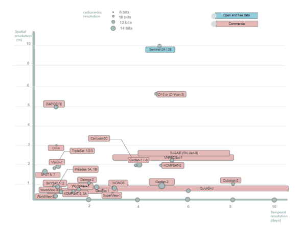 Figure 1: Comparison of imagery services for precision agricultural use
monitoring within field agriculture. The second factor is a high frequency lower than five days to supervise vegetation growth and repartition over time.
As with most other optical satellites, all very high-resolution optical satellites are operated in a sun-synchronous orbit, usually collecting data in the descending orbit.
The current offer of satellite imagery in 2021 has given multiple sensors for precision agriculture’s applications, as shown in (figure 1). The WorldView2/3/4 mission seems to offer the more precise imagery in terms of spatial and temporal resolution daily and under 1 m, while the open and accessible data are minimal to the Sentinel mission with a spatial resolution of 10 m in 5 days. Nevertheless, the Sentinel mission can have limits for applications that demand precise spatial resolution, as shown in figure 2. (1) Presents the variability within the field using the NDVI index, the 10 m spatial resolution allows to limit the areas demanding intervention.
The sensors offer a general spectral resolution of 4 bands in visible and near-infrared (VNIR) spectrum for the most captors, while other sensors allow more advanced analysis using VNIR and SWIR bands for Sentinel 2 and WorldView2/3 missions. The SWIR bands allow the measurement of water content, leaf temperature photosynthesis, transpiration, stomatal conductance, and internal CO2 content by extracting several vegetation indices like NDWI, NMDI, MSI to detect genotype effect and monitor drought [21], while the VNIR bands give information about chlorophyll absorption and monitor vegetation’s health and productivity. VNIR permits the generation of yield maps, phenotype crop performance, evaluation of the disease in the field, evaluation of expansion and suitability, and precision irrigation use.
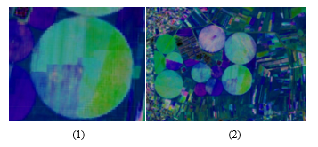 Figure 2. NDVI index extracted from Sentinel 2 imagery
6. Future Generation Satellite Missions
6.1. Pléiades Neo
Airbus will launch in early 2021 its most advanced constellation that will provide optical 100% available commercial imagery, with 0.3 m spatial resolution. Its constellation formed of 4 satellites operated in the same sun-synchronous orbit will allow a high revisit time twice daily at 46° off-Nadir and daily 30° off-Nadir. The radiometric resolution is planned for 12 bits and a spectral resolution of 6 multispectral bands (Blue, Blue, Green, Red, Red Edge, Near-infrared) and the panchromatic band. The mission is conceived for a lifetime of 10 years.
6.2. Blacksky Global
BlackSky Global, a startup company, founded in 2013, is a new “satellite imaging as a service” provider aimed at commercializing access to high-performance satellite imagery. BlackSky constellation owned by Spaceflight Industries now includes six satellites. The company is on track to add ten more satellites to its constellation by the end of 2021.The company’s long-term goals are to deploy 30 satellites by 2023 and possibly 60 years after, depending on the market demand. The constellation capabilities enable a unique revisit capacity of a few hours or less with a spatial resolution of up to 75 cm and low pricing [22].
6.3. URTHEDAILY
The constellation of UrtheDaily is planned to be launched in 2022. Its specification is its design to be compatible with Sentinel, RapidEye, and Landsat missions to ease cross-calibration with trusted references and to minimize the effects of atmospheric variations. UrtheDaily is designed to acquire high-quality, multispectral imagery at 5 m spatial resolution with daily revisit time. The constellation is initially designed with eight satellites to be launched in 2022.
6.4. Planet Imagery
Planet Labs is an American private Earth-imaging company. Founded in December 2010, Planet designs, builds and launches satellites by using lean, low-cost electronics. The Constellation of SuperDoves operates more than 150 satellites that together provide a dataset of Earth observation imagery with a unique combination of coverage, frequency, and resolution. It launches new satellites every three or four-month [23] . The constellation had added 48 SuperDoves to the constellation in January 2021
6.5. GAOFEN 14- 13 (GF-13, GF-14)
An optical stereo mapping satellite in a sun-synchronous orbit (GF-14) and a geostationary earth observation satellite (GF-13). The Gaofen satellites form a series of civilian Earth observation satellites that comprises more than 20 satellites. They are part of China’s High-definition Earth Observation System (CHEOPS). GF-13and GF-14 are government-funded programs designed to provide real-time global surveillance data. They will be mainly used for land surveys, crop yield estimation, environmental management, meteorological early warning and forecast, and disaster prevention and reduction, providing information services to develop the national economy.
7. Conclusion
This paper presented the principle satellite services freely and commercially available for different precision agriculture applications. The results showed that recent PA applications are demanding more precise imagery. The recent technological advances have permitted a steady advance in spatial resolution attending 0.3 m and twice-daily revisit time with a sensibility reaching 14 bits. The current trends of satellite imagery are towards 100% commercially available imagery with lower costs and fast access that allows a large delivery to a community of users, especially for agricultural concerns. Future progress conduct trends towards using large nanosatellites constellation to satisfy a large demanding community with an extending lifetime reaching 15 years, leading to the prolongation of the longevity of the missions and consistent supply of highly calibrated data.
Conflict of Interest
The authors declare no conflict of interest.
- M. Shepherd, J.A. Turner, B. Small, D. Wheeler, “Priorities for science to overcome hurdles thwarting the full promise of the ‘digital agriculture’ revolution,” Journal of the Science of Food and Agriculture, 100(14), 5083–5092, 2020, doi:https://doi.org/10.1002/jsfa.9346.
- M.C.F. Wei, L.F. Maldaner, P.M.N. Ottoni, J.P. Molin, “Carrot Yield Mapping: A Precision Agriculture Approach Based on Machine Learning,” AI, 1(2), 229–241, 2020, doi:10.3390/ai1020015.
- A.H.E. Nahry, R.R. Ali, A.A.E. Baroudy, “An approach for precision farming under pivot irrigation system using remote sensing and GIS techniques,” Agricultural Water Management, 98(4), 517–531, 2011, doi:10.1016/j.agwat.2010.09.012.
- Y. Lan, Z. Huang, X. Deng, Z. Zhu, H. Huang, Z. Zheng, B. Lian, G. Zeng, Z. Tong, “Comparison of machine learning methods for citrus greening detection on UAV multispectral images,” Computers and Electronics in Agriculture, 171, 105234, 2020, doi:10.1016/j.compag.2020.105234.
- J. da R. Miranda, M. de C. Alves, E.A. Pozza, H. Santos Neto, “Detection of coffee berry necrosis by digital image processing of landsat 8 oli satellite imagery,” International Journal of Applied Earth Observation and Geoinformation, 85, 101983, 2020, doi:10.1016/j.jag.2019.101983.
- G. Sambasivam, G.D. Opiyo, “A predictive machine learning application in agriculture: Cassava disease detection and classification with imbalanced dataset using convolutional neural networks,” Egyptian Informatics Journal, 2020, doi:10.1016/j.eij.2020.02.007.
- A. de Lara, L. Longchamps, R. Khosla, “Soil Water Content and High-Resolution Imagery for Precision Irrigation: Maize Yield,” Agronomy, 9(4), 174, 2019, doi:10.3390/agronomy9040174.
- L. Tao, J. Li, X. Chen, Y. Su, Y. Zhang, W. Wang, X. Shi, “Estimation of actual irrigation area using remote sensing monitoring method in Hetao Irrigation District,” in 2014 IEEE Geoscience and Remote Sensing Symposium, 2367–2370, 2014, doi:10.1109/IGARSS.2014.6946947.
- T. Wu, J. Luo, W. Dong, Y. Sun, L. Xia, X. Zhang, “Geo-Object-Based Soil Organic Matter Mapping Using Machine Learning Algorithms With Multi-Source Geo-Spatial Data,” IEEE Journal of Selected Topics in Applied Earth Observations and Remote Sensing, 12(4), 1091–1106, 2019, doi:10.1109/JSTARS.2019.2902375.
- A. Ashapure, J. Jung, A. Chang, S. Oh, J. Yeom, M. Maeda, A. Maeda, N. Dube, J. Landivar, S. Hague, W. Smith, “Developing a machine learning based cotton yield estimation framework using multi-temporal UAS data,” ISPRS Journal of Photogrammetry and Remote Sensing, 169, 180–194, 2020, doi:10.1016/j.isprsjprs.2020.09.015.
- B. Zheng, S.W. Myint, P.S. Thenkabail, R.M. Aggarwal, “A support vector machine to identify irrigated crop types using time-series Landsat NDVI data,” International Journal of Applied Earth Observation and Geoinformation, 34, 103–112, 2015, doi:10.1016/j.jag.2014.07.002.
- D. Arvor, M. Jonathan, M. Simoes, V. Dubreuil, L. Durieux, “Classification of MODIS EVI time series for crop mapping in the state of Mato Grosso, Brazil,” International Journal of Remote Sensing, 32, 7847–7871, 2011, doi:10.1080/01431161.2010.531783.
- G. Rondeaux, M. Steven, F. Baret, “Optimization of soil-adjusted vegetation indices,” Remote Sensing of Environment, 55(2), 95–107, 1996, doi:10.1016/0034-4257(95)00186-7.
- S. Sankaran, J.J. Quirós, P.N. Miklas, “Unmanned aerial system and satellite-based high resolution imagery for high-throughput phenotyping in dry bean,” Computers and Electronics in Agriculture, 165, 104965, 2019, doi:10.1016/j.compag.2019.104965.
- I. Dowman, K. Jacobsen, G.S. Konecy, High Resolution Optical Satellite Imagery, Whittles Publishing, 2012.
- Y. Palchoudhuri, R. Valcarce-Diñeiro, P. King, M. Sanabria-Soto, “Classification of multi-temporal spectral indices for crop type mapping: a case study in Coalville, UK,” The Journal of Agricultural Science, 1–13, 2018, doi:10.1017/S0021859617000879.
- N. Torbick, D. Chowdhury, W. Salas, J. Qi, “Monitoring Rice Agriculture across Myanmar Using Time Series Sentinel-1 Assisted by Landsat-8 and PALSAR-2,” Remote Sensing, 9(2), 119, 2017, doi:10.3390/rs9020119.
- L. Han, G. Yang, H. Dai, B. Xu, H. Yang, H. Feng, Z. Li, X. Yang, “Modeling maize above-ground biomass based on machine learning approaches using UAV remote-sensing data,” Plant Methods, 15(1), 10, 2019, doi:10.1186/s13007-019-0394-z.
- S.K. Seelan, S. Laguette, G.M. Casady, G.A. Seielstad, “Remote sensing applications for precision agriculture: A learning community approach,” Remote Sensing of Environment, 88(1), 157–169, 2003, doi:10.1016/j.rse.2003.04.007.
- G. Li, Z. Cheng, D. Lu, W. Lu, J. Huang, J. Zhi, S. Li, “Examining hickory plantation expansion and evaluating suitability for it using multitemporal satellite imagery and ancillary data,” Applied Geography, 109, 102035, 2019, doi:10.1016/j.apgeog.2019.102035.
- P. Braga, L.G.T. Crusiol, M.R. Nanni, A.L.H. Caranhato, M.B. Fuhrmann, A.L. Nepomuceno, N. Neumaier, J.R.B. Farias, A. Koltun, L.S.A. Gonçalves, L.M. Mertz-Henning, “Vegetation indices and NIR-SWIR spectral bands as a phenotyping tool for water status determination in soybean,” Precision Agriculture, 22(1), 249–266, 2021, doi:10.1007/s11119-020-09740-4.
- R. Nasini, T.G. LoB, A. Oddone, “BlackSky constellation: very high resolution optical data for multi-daily revisit,” 7.
- C. Yang, C. Yang, “High resolution satellite imaging sensors for precision agriculture,” Frontiers of Agricultural Science and Engineering, 5(4), 393–405, 2018, doi:10.15302/J-FASE-2018226.